Gerald McCormack, CIHT

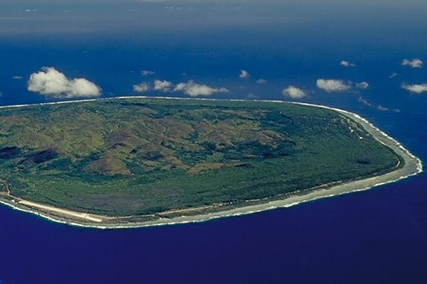
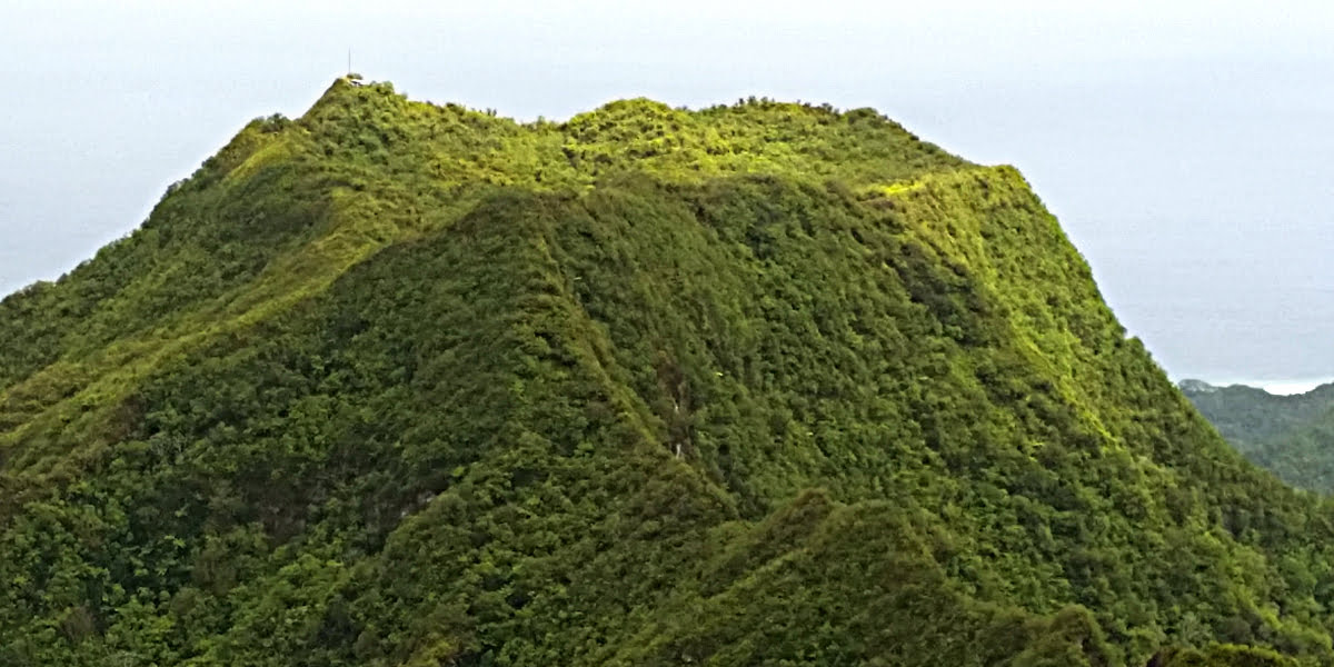
A view of Mangaia north to south. The outer green belt is the raised fossil reef (makatea), which surrounds the inland volcanic hills. (Photo Ewan Smith)
In the Quarantine Quiz (CINews 29 May) the oldest island in the Pacific was listed as Mangaia at 18 million years (Ma). This idea gained popularity with the 2010 publication entitled “Tangi ke – Welcome to Mangaia – The oldest island in the Pacific”, by the Mangaia Historical and Cultural Society and the University of the South Pacific.
It is simply not true, there are many islands in the Pacific much older, and, within the Cook Islands, all the Northern Atolls are more than twice as old as Mangaia.
The Hotspots
The Southern Group islands formed from two long-lived “hotspots” to the southeast. The oldest dated-island in this complex chain is Mangaia at around 19.5Ma (million years). This makes Mangaia the oldest dated-island in the Cook-Austral chain. (See the illustration)
Mangaia originated 1,900km to the southeast at the Macdonald Hotspot, which is growing yet another island, presently within 50m of the surface. The Pacific Plate carries islands to the northwest, away from their hotspots, at about 10cm/year which accounts for the distance from Mangaia to the Macdonald Hotspot.
The Cook-Austral hotspot chain. The tracks of the Macdonald and Arago hotspots for more than 50 million years.
Other islands with evidence of a Macdonald origin are Rapa, Raivavae, Tubuai, Rurutu and Rimatara. In addition, some geologists conclude there was another undiscovered hotspot southeast of Raivavae that played a later role in the formation of Raivavae, Tubuai and various seamounts. The story is still unfolding.
The Southern Group atoll of Palmerston is of unknown age and origin. It might be a very old island like the Northern Group atolls, or it might be the most westerly member of the Cook-Austral hotspot chain. In the latter case, it probably originated at the Arago Hotspot, which is now a small seamount 130km southeast of Rurutu. If this is the case, would Palmerston be older than Mangaia?
The islands formed by the Arago Hotspot include Aitutaki, Ātiu, Ma‘uke and Miti‘āro. Of these islands, only Ātiu is well-dated. It is 850km from Arago and dated at 8Ma. Palmerston is 1,400km from Arago giving it an estimated age of 13Ma. If Palmerston formed at Arago, Mangaia would still be the oldest island in the Cook-Austral chain.
In recent years scientists have shown that the Macdonald and Arago hotspots also made seamounts and islands in the Tokelau chain and in the Tuvalu-Gilbert chains, respectively. There the islands are an amazing 60-80Ma, and there is more speculative evidence that these hotspot tracks continue into western Micronesia to islands older than 100Ma.
Mangaia, as a child of the Macdonald Hotspot, is the oldest in the island-dense Cook-Austral archipelago. However, compared to the Macdonald’s oldest offspring in the Tokelau, Mangaia is a teenager.
The Manihiki Plateau
The Northern Group islands are all much older than Mangaia. The massive Manihiki Plateau formed between 125-120 million years ago. It soon broke into separate sections, three of which drifted away: one to Colombia; one to Antarctica; and, one to New Zealand as the Hikurangi Plateau. The remaining section, the Manihiki Plateau, became partially divided by deep troughs.
Between 100Ma and 60Ma there were a number of small eruptions on the plateau, forming a few seamounts along with the islands of Suwarrow, Pukapuka, Nassau, Manihiki and Rakahanga. When Penrhyn grew to the east of the plateau is unknown, but is it probably more than 50Ma. All Northern Group islands are much older than Mangaia.
Since its formation near the surface the plateau has been slowly sinking. The highest section is presently about 2,500m above the surrounding seafloor, which is typically about 5,000m below sea level.
The Pacific Tectonic Plate
The Pacific Ocean overlies two main tectonic plates, the largest being the Pacific Plate. This plate started to grow about 180Ma and it has pushed other plates away to become the largest tectonic plate in the world. The edge of this plate is known as the “Ring of Fire” because it is associated with intense volcanism and earthquakes. In our area, the Pacific Plate’s western boundary is the Tonga Trench, where it subducts under the Australian Plate.
Like the Cook Islands, islands on the Pacific Plate have grown by within-plate volcanism, mainly over “hotspots”. In the western South Pacific, on the Australian Plate there are many large islands in Fiji, Vanuatu, Solomons and New Caledonia, which usually have much older foundations than Mangaia. Fiji, for example, has rocks dated to around 40Ma; the oldest in the Solomons are around 60Ma.
Comparing islands on the Australian Plate with islands on the Pacific Plate, such as Mangaia, is like comparing apples with oranges. We will leave the Australian Plate and focus on Pacific Plate, where many of the islands are more than twice as old as Mangaia.
Another contest?
The wave eroded coastal cliff of the uplifted fossil reef (makatea). Cliff is approximately 15 meters high.
While Mangaia is not the oldest island on the Pacific Plate, it can win a restricted contest for the oldest island with exposed volcanic rocks.
When volcanic islands grow on the Pacific Plate their volcanic cores are soon surrounded by an ever-thicker limestone reef, grown by corals. Within about 10Ma the volcanic core sinks below sea level, leaving a lagoon surrounded by a coral reef – an atoll. For example, when Eniwetok atoll in the Marshall Islands was drilled in 1952 there was 1,300m (4,200ft) of limestone before they hit the volcanic core. While the sinking of an island is incredibly slow, given 70Ma the effect can be very dramatic.
All but a few of the old islands on the Pacific Plate have limestone caps completely covering their original volcanic cores. The few exceptions just happen to be six islands in the Australs (Rimatara and Rurutu) and Southern Cooks (Mangaia, Ātiu, Ma‘uke, Miti‘āro). These are the uplifted makatea islands.
The makatea islands subsided until they were low volcanic hills surrounded by a wide fringing reef of limestone. At that stage, they stopped sinking and were uplifted so that today each has a dry fossil reef surrounding inland volcanic hills. In our case, the uplift started about 2Ma and Mangaia is the most spectacular, with its fossil reef to 75m elevation and the central hill of Rangimotia at 170m.
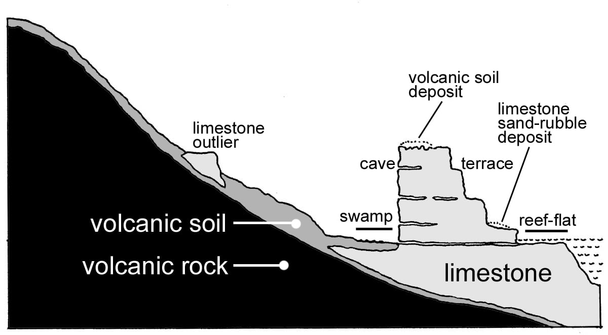
Cross-section of Mangaia showing inland volcanic hills, swampy gulch and uplifted limestone fossil reef. The coastal image above shows the cliff on the inside of the reef flat. The steps on the outer uplifted reef formed a different times when the sea level was much than at present.
Mangaia is the oldest of these six makatea islands, and I believe this makes it the oldest island on the Pacific Plate with exposed volcanic rocks.
What about other uplifted islands, such as Niue, Makatea (Tuamotu) and Henderson? While Niue and Makatea are much older islands than Mangaia they have no exposed volcanic rocks, because they were atolls at the time of their uplift.
Although Mangaia is not the oldest island in the Pacific or the Cook Islands, it is definitely the oldest dated island in the Cook-Austral archipelago. And, it is probably the island with the oldest exposed volcanic rocks on the Pacific Plate.
Author’s notes
First published CI News (04 June 2020 condensed) and CI Herald (10 June 2020 in full). This article is the full version.