


Gerald McCormack, CINHT,

Illustration of Mangaia – Judith Künzle
About two million years ago, when Mangaia was around 17 million years old, the whole island started to lift upward out of the sea. At that time, or sometime later, Mangaia was a wide coastal plain of exposed reef-rock adjoining a rounded central mountain, about 100 metres high. The exposed reef-rock is known in Mäori as makatea.
As the streams carried the volcanic soil off the mountain to the sea they deposited large amounts on the exposed reef-rock. Today, this red soil makes fertile pockets on the makatea, typically planted with Tuitui (Candlenut, Aleurites moluccanus) and subsistence food crops.

Illustration of central mountain surrounded by Makatea – Judith Künzle
The exposed reef-rock was also modified by rainwater. The moisture dissolved every surface into a crumbling layer of jagged-edged crests and holes, while streamlets of water cut potholes and dissected the plain into a network of irregular trenches, often several metres deep.
Along the inner boundary of the makatea, where it lay in direct contact with the volcanic soil, the water was particularly aggressive in undercutting the limestone so that it fell down to make an erosional gulch with a vertical cliff. As the island continued to uplift and the gulch grew deeper, and the streams dissolved tunnels through the makatea at different levels. These old drainage tunnels, now well above sea level, are the makatea caves, traditionally used as burial sites.
The lower slopes of the erosional gulch are the most fertile soils on Mangaia, and the swamps are used to grow Taro.
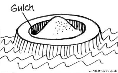
Illustration depicting formation of the Gulch – Judith Künzle
Today, the central mountain is 169 metres high; the swamps in the gulch are a couple of metres above sea level; and the inner makatea-cliff reaches vertically to 60 metres, which is the typical maximum height of the makatea.
The outer side of the makatea is not a vertical cliff like the inner side. It has a series of terraces and notches.
Prominent terraces surround the island at 15 and 42 metres above sea level. To the east and south there is another terrace at 27 metres, while on the west there is a notch at 23 metres.
The terraces and notch were cut by the sea when it was much higher than at present.
The 15 metre terrace is the one which supports the Airport, the Airport-Oneroa-Tamarua Road, and the lower level of Oneroa Village. This sloping terrace formed about 100,000 years ago during the high sea stand of the warm Last Interglacial Period. At that time the waves cut into the makatea limestone to form a landward cliff, and, in the sea, coral growth and erosion formed spurs and grooves. Later, as the earth cooled, more water was locked away as ice, the sea level fell again, and the old reef was left high and dry. During the last 6,000 years, since the sea settled at about its present level, the waves have been eating into the old spurs-and-grooves to make a new reef-flat and landward cliff.
First published CINEWS (25 June 1993)


